Centro Histórico de Campeche, UNESCO World Heritage Site
Campeche sits on the western edge of the Yucatán Peninsula, a small state squeezed between the Gulf of Mexico and the jungle interior that stretches toward Guatemala. It is one of the least-visited parts of the peninsula — and that is precisely its value. You get a UNESCO-listed walled capital Maya ruins without overtourism, a vast biosphere reserve, and Gulf coast towns where life moves at a fishing-village pace, all within a compact geography.
This guide covers the practical core: what to see, how to reach it, how much time to allow, and how to combine Campeche's highlights into a working itinerary.
Where to Base Yourself
For most visitors, San Francisco de Campeche is the clear starting point. The historic centre is compact, walkable, and well connected by ADO bus and the Tren Maya to Mérida, Escárcega, and beyond. Staying inside the walled city puts you within walking distance of the cathedral, plazas, Calle 59's restaurants, and the Malecón. Hotels range from modest guesthouses to converted colonial houses with interior courtyards and rooftop terraces.
Ciudad del Carmen serves as a second base for the coast and Laguna de Términos — practical if you are flying into its regional airport or prioritising dolphin tours. For Calakmul, Xpujil is the functional overnight base: a small town with basic hotels, a few restaurants, and the access road to the ruins and biosphere reserve roughly 60 km further south.
Two or three days cover the city and Edzná. Add a day for the coast (Isla Aguada or Sabancuy) or an overnight for Calakmul.
The Walled Historic Centre
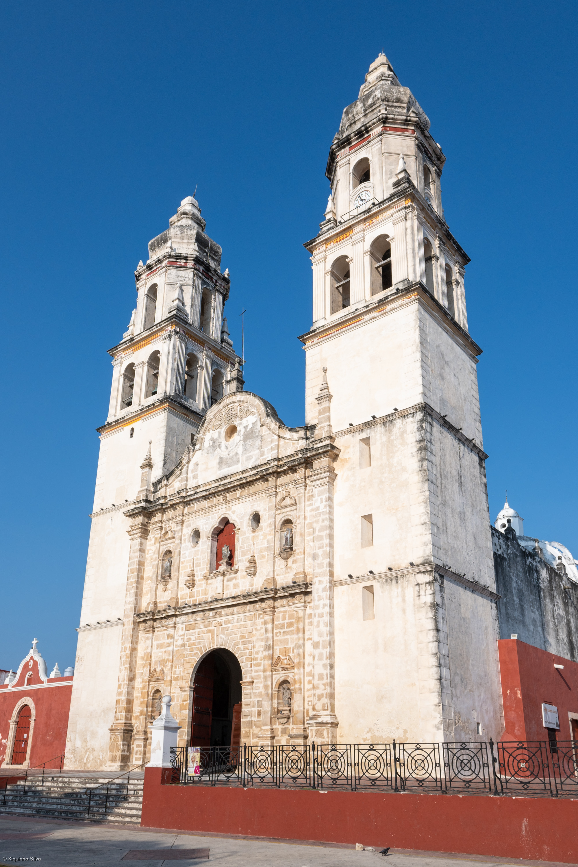
Campeche's UNESCO-inscribed centro histórico is the anchor of any visit. The city was founded in 1540 on a Maya settlement called Can Pech, and its position as the Spanish Empire's main port for Yucatán made it a target. Pirate attacks in the 16th and 17th centuries — including Sir Henry Morgan's sack of the city in 1663 — led to the construction of 2.5 km of stone walls, six bastions, and two fortified gates that still define the urban layout today.
A practical walking route starts at the Puerta de Tierra, the sea-facing gate on the western side of the walls. Climb the ramparts for a view across the Malecón and the flat Gulf horizon. From here, walk inland along Calle 59, a pedestrianised street lined with restored colonial façades in pink, ochre, and turquoise, connecting to the Plaza Principal. The Catedral de San Francisco de Asís anchors the north side of the plaza, with open-air cafés under the portales ideal for a slow morning coffee.
Baluarte de San Carlos, near the Puerta de Mar, houses the Museo de la Ciudad with exhibits on the city's pirate history and maritime trade. Baluarte de la Soledad holds the Museo de Arquitectura Maya, displaying stelae and carved stone pieces from Edzná and Calakmul. The bastions are free to enter during daytime hours; the small museums inside charge modest fees (around 50–60 MXN, bring cash).
The Malecón runs 3.5 km along the seafront boulevard. Late afternoon before sunset is the best time: locals jog, families sit on benches, and food carts sell marquesitas and fresh coconut water. It is flat, well-lit, and bordered by a low seawall — one of the most pleasant urban walks on the Gulf coast.
Edzná: The Five-Story City
Edzná lies 60 km southeast of Campeche city and is the most accessible Maya ruin in the state. It makes a straightforward half-day trip, reachable by colectivo (shared taxi) from the city's second bus terminal, by ADO bus, or by rental car along Highway 180.
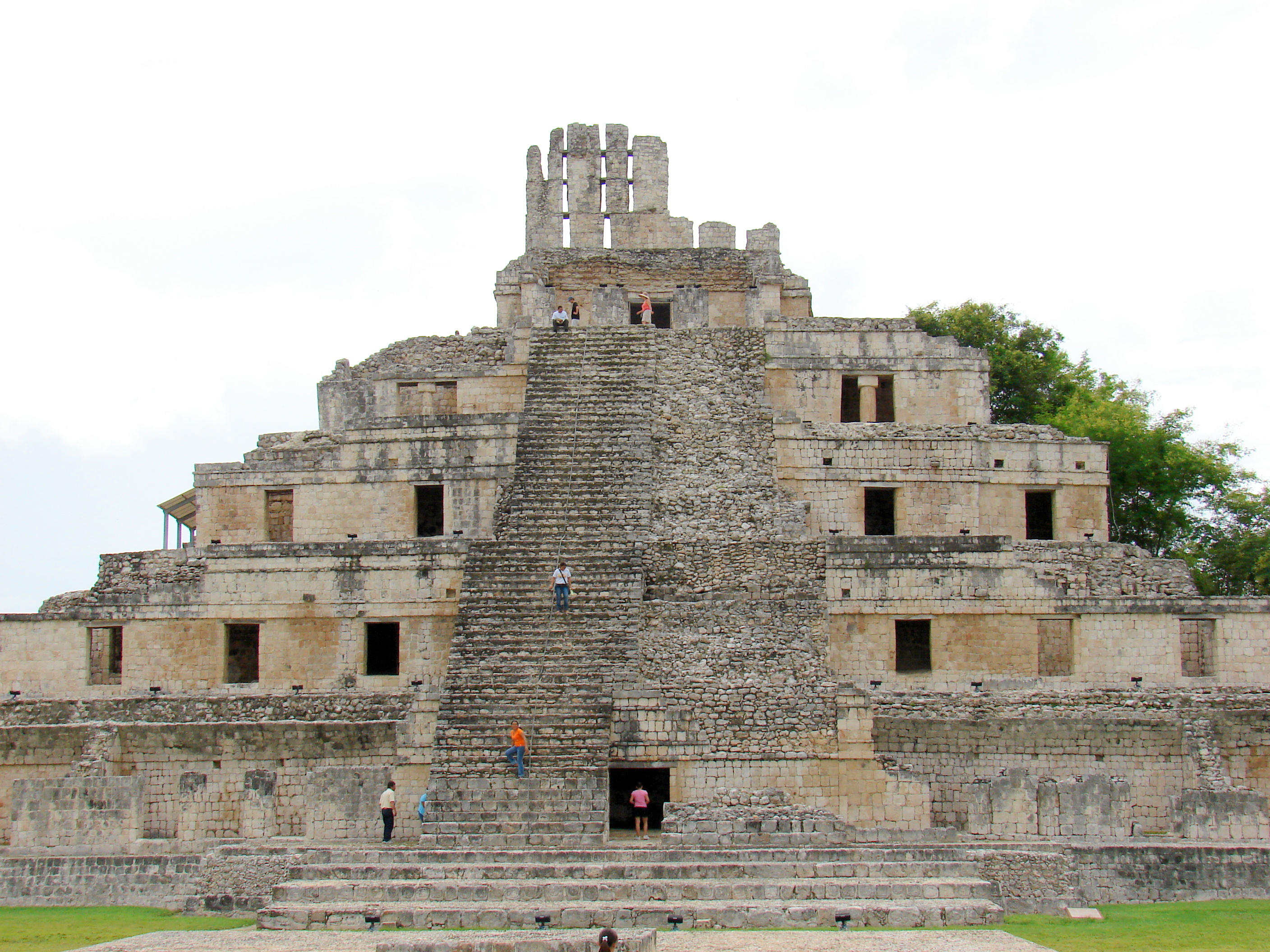 Edzná's Five-Story Building, the largest structure at the site
The site's centrepire is the Edificio de los Cinco Pisos, a five-story temple platform rising 35 meters above the plaza — unusually tall for the region and one of the few Maya structures built with vaulted stone rooms rather than simple stair-step levels. The main plaza is large and open, surrounded by a sacbé (raised causeway), a ball court, and the Temple of the Masks, which preserves two stucco masks of the sun god at the base of its staircase.
Edzná gets few visitors compared to Calakmul or the major Yucatán ruins. Even at midday you may have the main plaza largely to yourself. The site opens at 8 am; arriving at opening gives you the best light and the coolest temperatures. There is no shade on the open platforms — a hat and water are essential. Entry fee is approximately 85 MXN for foreigners. Allow two to three hours to walk the main structures and the short jungle path to the secondary plazas.
The site is managed by INAH (Instituto Nacional de Antropología e Historia). There is a small ticket office at the entrance and basic toilets, but no café or shop inside the archaeological zone — bring snacks and water. A licensed guide can be hired at the entrance for a walking tour lasting about 90 minutes; fees are negotiable but expect around 500–700 MXN for a small group.
GuideEdzná Travel Guide: Day Trip from Campeche CityEdzná is Campeche state's most accessible major ruin — roughly an hour from the walled city — centered on the Temple of the Five Stories and a compact acropolis complex. This guide outlines opening strategy for heat and light, car and tour logistics, typical visit length, and smart pairings such as a Champotón seafood lunch on the return drive. It is the right first ruin day for most Campeche itineraries before committing to Calakmul's long jungle drive.Open
The Forts: San Miguel and San José
Two hilltop forts sit outside the walled centre, both worth the walk. Fuerte de San Miguel, on the southwest edge of the city, houses the Museo Arqueológico de Campeche — the state's best collection of Maya jade, ceramics, and jaguar-altar carvings, many from Calakmul. The fort itself is an 18th-century construction with wide ramparts, a moat, and a view over the city and the Gulf. Plan about an hour for the museum; entry is approximately 60 MXN.
Fuerte de San José el Alto, on the northeast side, is larger and less visited. It overlooks the city from a higher elevation and houses a smaller museum focused on the military history of the peninsula. Getting there involves a steep walk or a short taxi ride from the centro. Combined with San Miguel, the two forts give you a clear picture of how the defensive system worked — the walls guarded the harbour, while the forts covered the approaches from the landward side.
Calakmul: The Jungle Kingdom
Calakmul is the most demanding destination on the Campeche itinerary, and for many visitors the most rewarding. The ruins sit deep inside the Calakmul Biosphere Reserve, 170 km south of Campeche city via Highway 186 through Xpujil — a full day's drive round trip, or better, an overnight stay near Xpujil.
The road from Escárcega to Xpujil is Highway 186, 130 km of two-lane road through tropical forest. From Xpujil, 60 km of winding road leads to the archaeological zone entrance. The final stretch is narrow and winding with potholes after heavy rain — a vehicle with reasonable ground clearance helps.
Calakmul's Structure II is one of the largest Maya pyramids by volume, rising 45 meters above the forest canopy. The site covers a vast area with over 6,000 mapped structures, though only a fraction are cleared. Stelae — tall carved stone slabs recording royal lineages — are scattered through the site; more than 100 have been found, one of the largest concentrations in the Maya world.
Wildlife is part of the experience. Spider monkeys and howler monkeys move through the trees along the access road, and ocellated turkeys, toucans, and raptors are commonly seen. The reserve holds one of Central America's healthiest jaguar populations — seeing one is unlikely but possible.
Entry involves three separate fees paid at checkpoints along the access road: a biosphere reserve fee, a community fee, and the INAH archaeological zone entry. Combined, expect around 200–250 MXN total per person. The site opens at 8 am and closes at 5 pm. There are no services inside the zone — no food, no water, no shade beyond the Structures themselves. Bring a packed lunch, at least two liters of water per person, sunscreen, and insect repellent.
The most practical base is Xpujil, which has small hotels, a few restaurants, fuel, and ATMs. Accommodation is simple — concrete-block rooms with fans or basic air conditioning — but adequate for an early night before a dawn start at the ruins.
GuideCalakmul Travel Guide: Biosphere Reserve and Maya MetropolisCalakmul is a vast Maya city inside a biosphere reserve near Campeche's southern border, best approached with an overnight near Xpujil rather than a rushed day from the capital. This guide explains driving times, reserve fees, what to expect at Structure II and the stelae groups, wildlife etiquette, and how Calakmul compares to easier day trips like Edzná. It covers dry-season road notes, guide options, and how to slot Calakmul into a longer Campeche itinerary when you have two or more days for the jungle south.Open
The Gulf Coast: Isla Aguada, Sabancuy and Champotón
It is not the turquoise Caribbean of Quintana Roo — it is the Gulf of Mexico: flat, warm, shallow water, mud flats, mangrove estuaries, and a working fishery. That is its appeal: the coast as locals live it.
Sabancuy, 70 km east of Campeche city on Highway 180, is the closest beach town. It is quiet and low-key, with a long stretch of dark sand beach, a few beachfront restaurants serving the day's catch, and a handful of small hotels. Calm water makes it suitable for families with young children, though the colour of the water is brown-green rather than blue.
Champotón, near the mouth of the Champotón River about 60 km south of the capital, is a working fishing town known for seafood — particularly coconut-fried shrimp and pan de cazón (shark meat layered with black beans and tomato sauce, a Campeche specialty). It has a small malecón and a ferry connection across the river. It works as a lunch stop if you are driving south toward Escárcega.
Isla Aguada, a Pueblo Mágico since 2020, is 90 km from Campeche city on the tip of the Palmar Peninsula between the Gulf and Laguna de Términos. It is the best base on the coast for dolphin tours: resident bottlenose dolphins visit the lagoon year-round, and local cooperatives run small-boat tours lasting about two to three hours. Isla Aguada also has the neoclassical lighthouse (el Faro, built 1907), now hosting a small underwater archaeology museum with shipwreck artifacts and cannons. Buses from Campeche city run several times daily; the trip takes about one and a half hours.
Laguna de Términos, the large estuary that borders Isla Aguada, is one of Mexico's most important wetland ecosystems — a 7,000 km² protected area combining mangrove, petén (floating forest), and open lagoon. Boat tours from Isla Aguada or nearby Concordia operate through mangrove channels where you can see frigatebirds, herons, and river typically run 1,200–1,800 MXN per boat for a group of up to six people.
Guide5-Day Campeche Itinerary: City, Ruins, and Gulf CoastThis five-day Campeche itinerary balances the walled city, an Edzná ruin morning, a Gulf coast run to Champotón, and either a deep Calakmul overnight or extra city and cenote time near Hopelchén. It assumes a rental car, builds in heat-aware pacing, and offers a shorter variant if you skip the southern jungle. Link out to dedicated city, Edzná, and Calakmul guides for detail on each segment.Open
Food Worth Seeking Out
Campeche's cuisine is distinct from Yucatán's. The signature dish is pan de cazón: layers of shredded shark, black beans, seasoned tomato sauce, and fried tortilla, assembled like a casserole. It appears on menus across the state but is best in smaller restaurants and market stalls in the capital and along the coast.
Seafood dominates the coast. Try ceviche de caracol (conch) in Isla Aguada, coconut-battered shrimp in Champotón, and grilled robalo (snapper) in any coastal pueblo. The Mercado Principal in Campeche city is the place to eat locally and cheaply: panuchos, tamales de chipilín, and fresh fruit licuados.
Practical Planning Notes
Getting around Campeche depends on your tolerance for early starts and long drives. ADO and Sur bus services connect Campeche city with Mérida, Escárcega, Ciudad del Carmen, and major towns. For Edzná and Xpujil, colectivos (shared taxis) fill the gaps that scheduled buses leave open. For Calakmul, you will want either a rental car or an organised tour.
The best months to visit are November through March, when temperatures hover around 28–32°C and rainfall is low. April and May are the hottest — 38–42°C is common, and the combination of heat and humidity makes midday ruin visits genuinely taxing. Rainy season runs June through October; afternoon downpours are typical but usually brief. Hurricane season peaks September–October, though direct hits on Campeche are less common than on the Caribbean coast.
Cash is essential at smaller sites, lagoon docks, market stalls, and rural colectivo stands. ATMs are reliable in Campeche city and Ciudad del Carmen but sparse in smaller towns.
Campeche uses Central Time (UTC-6). Note the one-hour difference when crossing into Quintana Roo (UTC-5) toward Cancún or Chetumal.
| Quick reference | Detail |
|---|---|
| Best base | San Francisco de Campeche historic centre |
| Ideal trip length | 3 days city + Edzná; 5–7 days with Calakmul and coast |
| Best months | November–March |
| Calakmul road | Highway 186 via Xpujil; 60 km from Xpujil to ruins |
| Edzná drive time | 45–50 min from Campeche city |
| Isla Aguada bus | ~1.5 hours from Campeche city, several daily |
| Calakmul entry fees | ~200–250 MXN total across three checkpoints |
| Edzná entry | ~85 MXN |
| Fort San Miguel entry | ~60 MXN |
| Cash needed | Yes — small sites, rural transport, markets |