Printable guide
Campeche 7-Day Road Trip Itinerary Across the State
Updated
A complete seven-day driving route through Campeche State capital, Edzná, Chenes and Río Bec ruins, Calakmul biosphere, and the Gulf coast. Includes daily bases, drive times, entrance fees, and where to find fuel and food between sites.
A week reveals what makes Campeche State different from its neighbours: not just the walled capital and a single ruins day, but the full arc — colonial plazas, Edzná's Five-Story pyramid, the mask-covered Chenes facades around Hopelchén, the theatrical Río Bec towers near Xpujil, Calakmul's deep-jungle pyramids, and a final Gulf coast swing before departure.
This itinerary covers roughly 960 km over seven days — about 16 hours total behind the wheel. A rental car is essential. Public transport reaches Edzná and the Tren Maya stops at Xpujil, but the scattered Chenes and Río Bec sites, the Calakmul access road, and the remote coast are impractical without your own wheels.
Who this trip works for
Best for: travellers who want Maya architecture without the Yucatán crowds and are comfortable on secondary roads. The heat is real from March onwards — start early every day.
Not for: anyone who dislikes driving. There is no realistic bus-only version of this loop.
Pace: moderate. You move base every 1–2 nights. Each day has one major site and one secondary stop, with recovery time in the late afternoon when the heat peaks.
At a glance
| Day | Route | Overnight | Key site |
|---|---|---|---|
| 1 | Arrive Campeche, city walk | Campeche | Plaza de la Independencia, malecón |
| 2 | Campeche → Edzná → Hopelchén | Hopelchén | Edzná, Hochob |
| 3 | Hopelchén → Santa Rosa Xtampak → Xpujil | Xpujil | Santa Rosa Xtampak |
| 4 | Río Bec sites | Xpujil | Becán, Chicanná, Xpujil ruins |
| 5 | Xpujil → Calakmul reserve | Calakmul | El Hormiguero, Balamkú |
| 6 | Calakmul full day | Calakmul or Xpujil | Calakmul, biosphere drive |
| 7 | Xpujil → Champotón or Ciudad del Carmen → depart | Champotón | Seafood lunch, beach, return |
Total driving: ~960 km over 7 days Fuel stops: Campeche, Hopelchén, Escárcega, Xpujil. Top up before heading toward Calakmul. Cell coverage: reliable around Campeche City and Edzná; patchy on secondary roads south of Hopelchén; absent inside the Calakmul reserve. Download offline maps before Day 3.
Day 1 — Arrive and walk the walls
Fly into Campeche (CPE), connecting through Mexico City. Pick up the rental car at the airport — agencies on-site. Drive 20 minutes into the walled city, park near the bastions, spend the afternoon on foot.
Start at Plaza de la Independencia, ringed by the cathedral and the arcaded Portales. Walk south to Puerta de Tierra for the land gate, then follow the wall to the Baluarte de San Carlos, which houses a small museum of city defences. The bastions are well-signposted and the circuit takes about an hour.
Evening: walk the malecón as the sun drops. Calle 59, the pedestrian strip inside the walls, fills with restaurants. Keep it easy — early start tomorrow.
Where to stay: hotels inside the walled city grid for walking distance to dinner and tomorrow's departure. Book ahead December–March.
Day 2 — Edzná and the Chenes threshold
Leave by 7:30 to beat the heat. Edzná is 55 km southeast of Campeche, about an hour on paved highway. The site opens at 8:00.
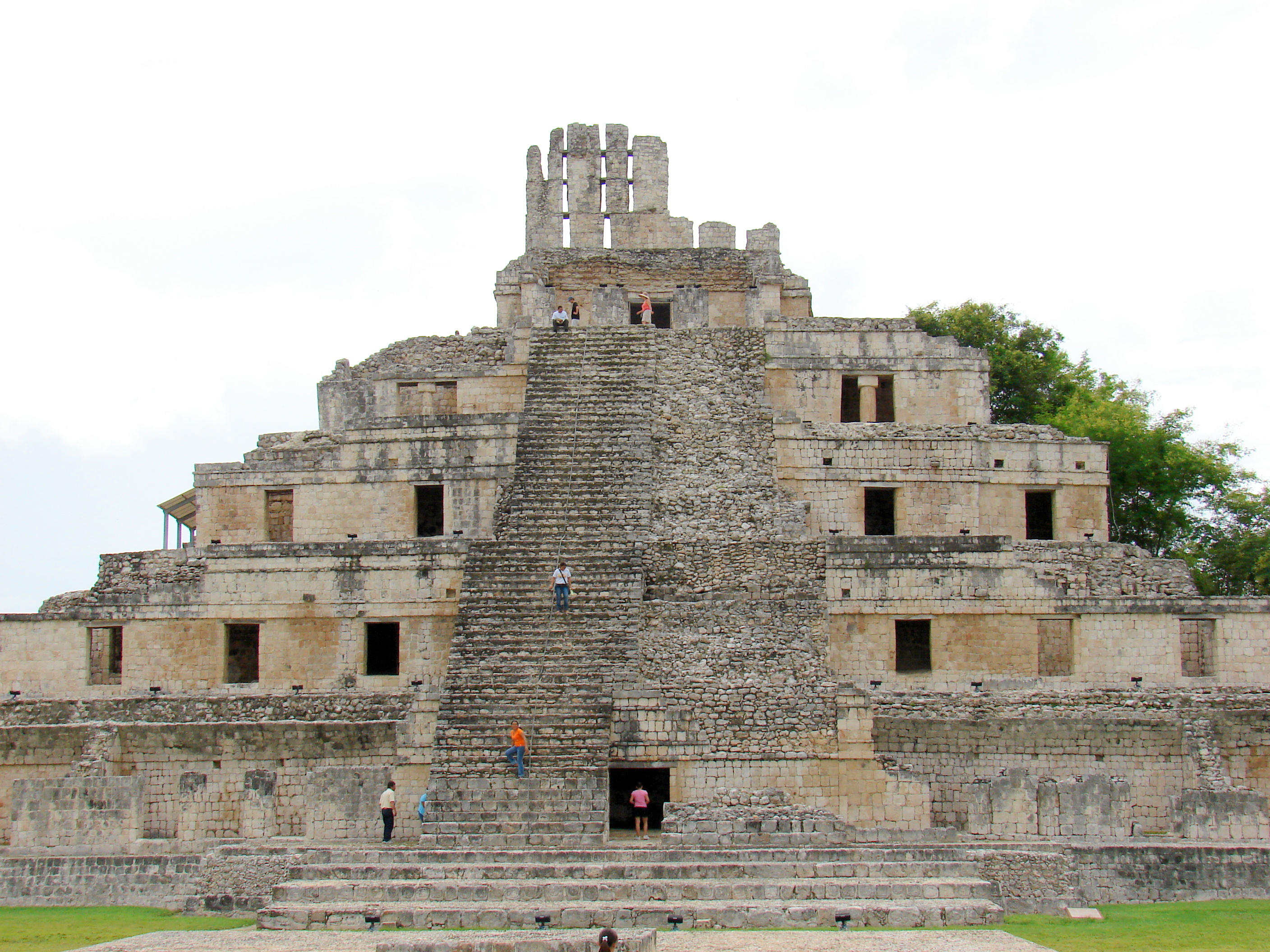
Edzná Five-Story Building rising above the plaza
Edzná is organised with geometric precision — a raised sacbe aligning the main plaza, the Great Acropolis, and the Temple of the Masks along a single axis. The Five-Story Building (Pirámide de los Cinco Pisos) dominates the acropolis: five stacked levels of vaulted rooms, not a solid stepped pyramid, among the tallest structures in the northern lowlands. Climbing is no longer permitted, but the view from the acropolis base gives a clear sense of scale. Budget 2–3 hours.
Entrance fee: ~95 MXN (verify locally). Bring water — the site is mostly exposed.
Return to the car, drive 30 minutes north to Hochob — a small Chenes-style site on the Edzná–Hopelchén road. The main structure's entrance is carved as a monster mouth, the signature Chenes motif, with elaborate stone mask decoration. Thirty minutes here. Rarely busy.
Late lunch in Hopelchén (La Palapa is a reliable stop). Overnight there — it is the last well-stocked fuel stop before the southern loop. Hotel Jaguar is the standard recommendation; Airbnb options exist for groups.
Driving today: ~140 km, two hours total.
Day 3 — Santa Rosa Xtampak and the road south
Today has the roughest access road on the trip. Santa Rosa Xtampak sits deep in scrub forest east of Hopelchén, at the end of a rough unpaved track. A sedan manages in dry weather; in wet season (June–October), check locally before committing. Allow three hours round-trip from Hopelchén, including a two-hour visit.
Santa Rosa Xtampak is the largest Chenes-era city and one of the least-visited major Maya sites in Mexico. The ceremonial core clusters around three plazas, with multi-room palaces and a partly restored pyramid. Howler monkeys in the canopy, no guard booth, no vendors, no sound except wind through the trees.
Back in Hopelchén for lunch, then drive 2.5 hours south on Highway 186 to Xpujil, the gateway town for the Río Bec ruins and Calakmul. Aim to arrive before dark — Highway 186 has wildlife crossings (peccaries, toucans, occasionally larger animals) and limited lighting at night.
Overnight Xpujil: Hotel Casa Las Lolas. Sazon Veracruz and Antojitos Doña Evita serve dinner.
Driving today: ~220 km, 4–5 hours including the Xtampak detour.
Day 4 — The Río Bec circuit
Xpujil sits at the centre of the Río Bec zone, with three major sites within 20 minutes of town. Start at Becán when it opens — 15 minutes east on Highway 186.
Becán is unusual for its defensive works: a deep dry ditch and earthen rampart encircle the ceremonial core, crossed by narrow causeways. Inside, Structure VIII and Structure IX are both climbable, and the views across the canopy show how isolated this city was. Budget 1.5 hours.
 Becán Structure IX in the Río Bec region
Chicanná, 15 minutes west, is the most elaborate facade in the Río Bec region: a main building carved as an enormous serpent's mouth — gaping stone jaws, filed teeth — blending Chenes and Río Bec styles. Budget 45 minutes.
The Xpujil ruins (10 minutes, town edge) have three classic Río Bec towers visible from the highway. Thirty minutes is enough for context before tomorrow's deeper sites.
Driving today: ~60 km, two hours total.
Day 5 — El Hormiguero and into the biosphere
El Hormiguero sits 60 km down a rough unpaved turnoff west of Highway 186 — the worst access road of the trip. Allow 60 minutes each way in a sedan, longer if wet. The site itself: two structures with the most elaborate Río Bec facade decoration, emerging from dense jungle. Budget 45 minutes plus driving time. Genuinely remote.
Return to Highway 186, fuel in Xpujil, then continue 75 km east into the Calakmul Biosphere Reserve. Three checkpoints charge separate fees as you drive in: biosphere access (~54 MXN), village cooperation (~54 MXN), and INAH ticket (~95 MXN). All cash. Total ≈200 MXN per person (verify locally).
Overnight inside the reserve at Hotel Mundo Maya Calakmul or camp at a CONANP-approved site. There is no other accommodation once you pass the checkpoint, and you want to be at the ruins by 8:00 the next morning.
Driving today: ~180 km, four to five hours including the Hormiguero detour.
Day 6 — Calakmul
Set out at first light. The archaeological zone is 30 minutes from Mundo Maya Hotel on a paved road through high tropical forest. Howler monkeys are loud at dawn; spider monkeys are common along the roadside.
Calakmul is one of the largest Maya cities ever mapped: over 6,000 structures across 20 square kilometres, of which only the central ceremonial precinct is cleared. Structure II rises over 45 metres — among the tallest Maya pyramids — and climbing it (where permitted) gives a view of unbroken canopy to every horizon. Structure I, to the north, is broader and held royal burials; four royal tombs have been found inside. Over 100 stelae have been recorded — the highest concentration in the Maya lowlands.
Budget 3–4 hours. There are no food vendors inside and limited shade on the cleared plazas.
In the afternoon, drive the reserve loop roads slowly. The bat cave (Volcán de los Murciélagos) is signposted; at dusk in the dry season, hundreds of thousands of bats spiral out. Check locally for current timing — it varies by season.
Return to Xpujil (1.5 hours) for the night if you prefer more comfort, or stay a second night in the reserve for a second dawn at the ruins.
Driving today: ~60 km inside the reserve, plus 100 km return to Xpujil if moving base tonight.
Day 7 — Coast and departure
The final leg swings west from Xpujil to the Gulf coast via Highway 186 and Highway 180. Two route options:
Option A — Champotón (seafood and beach): 3 hours west from Xpujil to Champotón, a fishing town at the mouth of the Río Champotón. The malecón restaurants serve pan de cazón, ceviche, and grilled snapper. The beach is grey Gulf sand — functional rather than scenic — but the seafood is the draw. Good for a final Campechano lunch before the 45-minute drive back to Campeche airport.
Option B — Ciudad del Carmen (full coastal town): 4 hours west from Xpujil via Escárcega. Ciudad del Carmen sits on Laguna de Términos with a waterfront malecón and the Zacatal Bridge to Isla Aguada. A lagoon boat tour for dolphins and mangroves is possible if you have an extra half-day. You can fly out of Carmen (CMC) or drive 3.5 hours back to Campeche (CPE).
Most travellers pick Option A: Champotón for lunch, then back to Campeche by late afternoon.
Driving today: 200–350 km depending on route, three to five hours.
Practical planning
When to go: November through April is the dry season and the best window for ruin-hopping. May and June are hot but workable. July to October brings heavy afternoon rain — unpaved access roads (Santa Rosa Xtampak, El Hormiguero) can become impassable after sustained downpours. Build a buffer day if travelling in those months.
Fuel: Fill in Campeche, Hopelchén, and Escárcega. There is a station in Xpujil, but it is the last before Calakmul. Never enter the reserve with less than three-quarters of a tank.
Cash: All ruin entrance fees, biosphere checkpoints, rural restaurants, and small-town hotels operate on cash. ATMs exist in Campeche, Hopelchén, Escárcega, Xpujil, and Ciudad del Carmen — withdraw before the Calakmul leg.
Packing essentials: 2L water per person on ruin days, hat, sunscreen, insect repellent, light long sleeves, flashlight, snacks for driving stretches, and offline maps (no live signal south of Hopelchén).
Tren Maya: The system lists both "Xpujil" and "Calakmul" stations. Book Xpujil — the "Calakmul" station is isolated jungle with no services or onward transport, leaving travellers stranded 60 km short of the ruins.
Time zone: Campeche is Central Time (UTC-6); Quintana Roo to the east is Eastern (UTC-5). If arriving from Cancún or Tulum, account for the shift in departure times.
Variations
Bus-and-shuttle version: Days 1–2 (Campeche and Edzná) work without a car via colectivo and taxi. For the southern loop, ADO runs Campeche–Xpujil, and local cooperatives offer shared transport would need to skip the scattered Chenes sites and Santa Rosa Xtampak. Budget an extra day for waiting time.
Archaeology-focused cut: Swap Day 7 for a second Calakmul day or add La Muñeca and Dzibilnocac (small Chenes sites near Hopelchén) to Day 3.
Coast-emphasis: Invert the loop — start Campeche–Champotón–Ciudad del Carmen Days 1–3, drive inland to Xpujil Day 4, Río Bec Day 5, Calakmul Day 6, fly out of Campeche or Chetumal Day 7.
Quick reference
| Detail | Value |
|---|---|
| Total km | ~960 |
| Drive time | ~16 hours over 7 days |
| Best months | November–April |
| Car | Essential. Sedan fine in dry season |
| Fuel stops | Campeche, Hopelchén, Escárcega, Xpujil |
| Cell | Good north of Hopelchén; patchy south; absent in Calakmul reserve |
| Cash | Required — most sites, rural restaurants, and checkpoints are cash-only |
| Calakmul fees | ~200 MXN total across 3 checkpoints (verify locally) |
| Edzná hours | 8:00–17:00 |
| Time zone | Central (UTC-6) |